Geologic Stability
Ensure your installation is designed correctly and on stable ground before investing in a geodetic reference station. As geologists and geodesists, we make the geologic assessment a core process for CORS installation to ensure proper drilling technique and long-term stability.
Geologic Assessment for Drilling
The proper assessment of onsite geology is a crucial step in monument selection and drilling/driving techniques.
Will the monument legs be installed in alluvium, bedrock, or something else?
Is the sediment fine-grained or coarse with cobbles and boulders?
How about the degree of fracturing in bedrock?
Are there expansive clays?
Will bedrock be encountered under the sediment?
We have observed our share of drilling challenges/failures due to underpowered systems or improper geologic evaluations.
VerQuin does it right the first time.
For deep-drilled braced monuments, the subsurface geology down to 35+ foot depths governs the style of the drilling technique and drill rig that is required, which in turn affects the cost, installation method, and materials. Fine-grained sediment can be drilled with an auger or hollow stem depending upon consolidation and competency. Bedrock often requires percussion drilling, but if highly fractured, the odex/advance casing is needed, as is the case for subsurface cobbles and boulders. These are more expensive drilling methods. The economical short-drilled (installed in bedrock) and short-driven (installed in sediment) braced monuments allow for a greater diversity of locations.

Geologic Assessment for Stability
A surprising number of continuously operating reference stations (CORS) are not only built with dubious monumentation but are on questionable bedrock or strata that cause false position timeseries not representative of a fixed point on the earth’s crust. Therefore, you need a geologist to assess ground stability and look for issues, such as slope failures, sackungens, or tension fractures and avoid or mitigate for expansive, clay-rich soils as well as artificial fill. In addition, production water wells, mining activity, water reservoir fluctuations, and even proximal vegetation can induce localized, non-tectonic motion in the position timeseries.
We make the geologic assessment part of the core criteria for CORS installation.
Below are examples of position time series where good geodetic monumentation was installed in suspect terrain. UNAVCO is the steward of these stations that are operated through the GAGE Facility.
P299
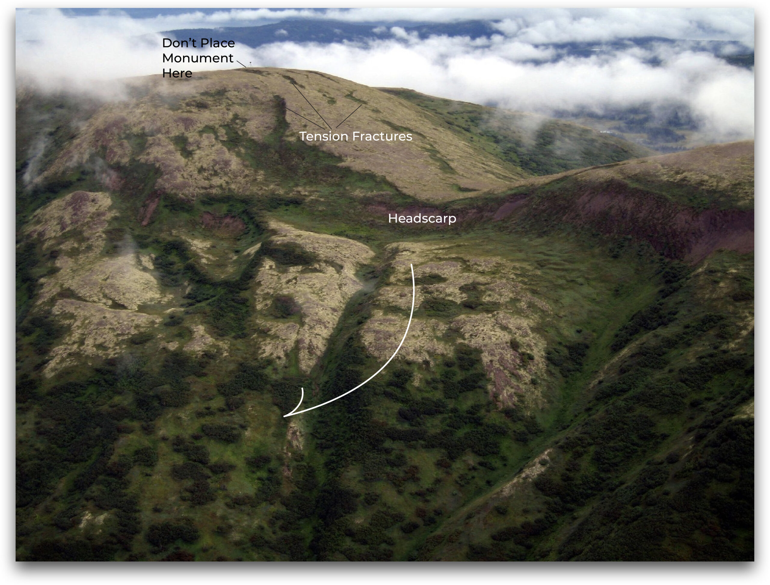
While the detrended position time series has low errors, annual transients in N, E and V components range from 10-30mm. This site was positioned on the headscarp of a slump (small landslide) in sub-vertical sedimentary strata and removed in April 2021. Though not on the slide feature itself, the monument legs spanned both a tension fracture and fault surface. The annual hydrologic impact on the fractured and faulted rock was suspected to be the cause of the transients.
P056
CORS are excellent for tracking subsidence from any number of causes. In this case, P056 is situated in a basin that is responding to groundwater withdrawal. The position time series relative to North America illustrates titling in the north component and collective subsidence in the Z component from non-recovered aquifer compaction. Note the acceleration of subsidence midway through California’s drought (2011-2017). If one’s aim is to measure aquifer compaction, the best tool for siting is to use InSAR to help guide placement of the station directly in the bulls-eye, where the maximum rate is, and will obviate tilting that occurs along the margin of compacting strata.
P340
Located on an active landslide, the position time series of P340 shows it slowly sliding downhill. The variations in the N and E components are interpreted to be caused by hydrologic-induced motion along the slip surface. This is clearly a non-tectonic signal.
P613
This detrended, non-linear position time series shows outliers associated with heavy snowfall years (when snow covers the radome) and also some odd transients. The station is located near the summit of Keller peak within a linear trough interpreted to be a graben structure of a sackung (sounds like “sakoon”) which is a type of ridge top spreading feature. Note how the larger transients follow the heaviest snowfall years, the 2010 El Mayor Cucapah earthquake, and the 2019 Ridgecrest earthquake sequence. So motion on this sackung appears to be both seismically and hydrologically induced.